Kaş kiralikvillanız.com.tr’deki ekonomik villa seçeneklerine bir göz atmakta yarar var. Hatta yakın olması nedeniyle kiralikvillaniz da bir seçenek olabilir. Bu yüzden yola çıkmadan ilkin kiralikvillaniz.com.tr ziyaret edip kıyaslamalı fiyatlar içinde en ideal villayı bulmanızı öneririm. Akdeniz bölgesinde yeni değişik rotalar ile alakalı bilgi almak isterseniz seyahat bloglarımıza bakabilirsiniz. Keşfetmeniz dileğiyle…
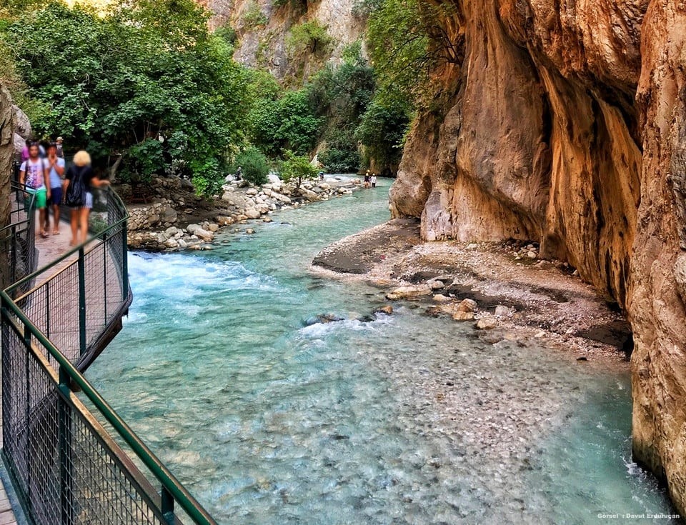
Muğla’nın Seydikemer ilçesinde bulunan Saklıkent Kanyonu, Türkiye’nin en popüler kanyonlarından biri olmakla beraber kelimenin tam anlamıyla doğa harikası bir turizm merkezidir. Saklıkent Kanyonu jeolojik çatlamalar sonucu oluştuğu tahmin edilmektedir. Üstelik yüksek taş duvarları sayesinde içerisine güneş geçmeyecek kadar uzundur. Suyun kolayca aşındırabileceği kalkerli arazide fay çatlaklarının da yardımıyla sarp ve derin bir kanyon oluşmuştur. Eşen Çayı’nın bir kolu olan Karaçay’ın serin ve derin suyunda Saklıkent Kanyonu içerisinde turlar yapılmaktadır.
Antalya-Muğla sınırını çizen Eşen Çayı’nın kolu olan Karaçay’ın oluşturduğu kanyon, 18 kilometre uzunluğa sahip ve duvarları ise 200 ile 600 metreye kadar çıkabilmektedir. Kanyonun bazı noktalarında kaya aralıkları 2 metreye kadar daralabilmektedir. Bu nedenle aralıklarda gökyüzünü görmek neredeyse imkansızdır. Saklıkent Kanyonu’nunda kızılçam, sedir ve karaçam ormanları yer almaktadır. Kanyon girişinde kızılçam ağaçları, yaklaşık 1000 metre ilerisinde de karaçamlar görülmektedir.
Karaçay’ın akıntısı çok şiddetlidir ve soğuk su akar. Kanyonun tabanı şiddetli akan suyla doludur, bundan dolayı su içinden geçmek imkansızdır. Giriş, kanyonun dik yamaçlarına demir çubuklarla tutturulan 200 metrelik tahta bir köprüyle yapılabilmektedir. Köprüden sonrasında oldukça soğuk olan güçlü karstik kaynaklar bulunur. Yaz mevsiminde piknik yeri olarak kullanılan bu alana yılda 180-210 bin turist gelmektedir.
Kanyonun çevresi 06.06.1996 tarihli Resmi Gazeteyle Saklıkent Milli Parkı ilan edilerek korumaya alınmıştır. 12390 hektarlık milli park alanında Kaş ve Fethiye’nin üçer köyü yer alır. Alanda görülen bitki toplulukları yüksekliğe göre Maki, Kızılçam, Karaçam ve Sedir olarak görülür. Antalya’nın batısında Patara’dan Kınık istikametine devam ederken Saklıkent sapağından 16 kilometre uzaklıkta olup,Xanthos Antik Kenti ‘ne çok yakındır.